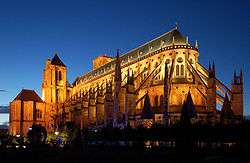
Bourges
Koordinatlar: 32°50′24″K 117°16′37″B / 32.84°K 117.27694°B
| Bourges | |||
| — Şehir — | |||
| Bourges şehri | |||
 |
|||
|
|||
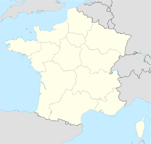 Bourges Saintes'in Fransa'daki konumu |
|||
| Koordinatlar: 32°50′24″K 117°16′37″B / 32.84°K 117.27694°B | |||
| Ülke | |||
|---|---|---|---|
| Bölge | Centre-Val de Loire | ||
| İlçe | Cher | ||
| Yönetim | |||
| - Belediye başkanı | Dominique Adenot | ||
| Yüzölçümü | |||
| - Toplam | 426,95 km2 (164,8 mi2) | ||
| Nüfus (26 Kasım 2009[1]) | |||
| - Toplam | 66.786 | ||
| - Yoğunluk | 128/km² (331,5/sq mi) | ||
| Zaman dilimi | PZD (-8) | ||

Bourges, Fransa'nın Centre-Val de Loire bölgesinde yer alan ve Cher departmantında yer alan bir komündür.[2] Şehrin nüfusu 26 Kasım 2009 tarihinde toplam nüfusu 66,786'dır.[3]
Kaynakça
- ↑ "Population Estimates". United States Census Bureau. http://www.census.gov/popest/data/cities/totals/2013/SUB-EST2013-3.html. Erişim tarihi: 2010-02-12.
- ↑ "Find a County". National Association of Counties. 26 Haziran 2015 tarihinde kaynağından arşivlendi. http://web.archive.org/web/20150626142102/http://www.naco.org/Counties/Pages/FindACounty.aspx. Erişim tarihi: 2009-11-26.
- ↑ Population of Michigan Regions and Statistical Areas, 2000 and 2010, at www.michigan.gov
Dış bağlantılar
This article is issued from Vikipedi - version of the 9/7/2016. The text is available under the Creative Commons Attribution/Share Alike but additional terms may apply for the media files.