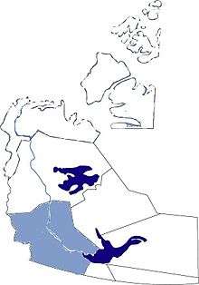
Dehcho Bölgesi

Kuzeybatı Toprakları ve Dehcho Bölgesi
Dehcho Bölgesi (İngilizce Dehcho Region), Kuzeybatı Toprakları'nın beş yönetim bölgesinden biridir. Altı yerleşimden oluşan bölgenin yönetim merkezi Fort Simpson'dadır.
Yerli halk
Bölgenin yerli halkları Kanada Atabasklarından olan Denetalardır.
Yerleşimler ve yönetim
Dehcho bölgesi idari açıdan şu yerleşimleri içerir:[1]
| Yerleşimin adı[2] | Denetaca adı ve çevirisi[2] | Governance[3][4] | Nüfus 2006[5] |
2001'dekinden farkı % | Koordinatlar |
| Fort Liard | ᐁᗴᐅᕠ ᑯᐁ Echaot'ı̨e Kų́ę́ «people from the land of the giants» | Hamlet | 583 | 10.0% | |
| Fort Simpson | ᒢᕄᐨᕄ ᑯᐁ Łı́ı́dlı̨ Kų́ę́ «place where rivers come together» | Village | 1,216 | 4.6% | |
| Jean Marie River | ᕫᐨᘛ ᑫᑌᕄ Tthek'éhdélı̨ «water flowing over clay» | First Nation - Designated Authority (TthedzehK'edeli First Nation) | 81 | 62.0% | |
| Nahanni Butte | Tthenáágó «strong rock» ᓇᐊ ᑌᐁ Nahɂą́ Dehé | Dene Band - Designated Authority (Nahanni Butte Dene Band) | 115 | 7.5% | |
| Trout Lake | ᓴᒼᐸ ᑫ Saamba K'e «?» | Dene Band - Designated Authority (Sambaa K'e Dene Band) | 86 | 22.9% | |
| Wrigley | Pedzéh Kı̨́ «clay place» ᕫᐨᘛ ᑯᐁ Tthedzéh Kǫ́ę́ | First Nation - Designated Authority (Pehdzeh Ki First Nation) | 122 | -33.0% | |
Kaynakça
Koordinatlar: 61°51′47″K 121°21′18″B / 61.86306°K 121.355°B
This article is issued from Vikipedi - version of the 6/18/2016. The text is available under the Creative Commons Attribution/Share Alike but additional terms may apply for the media files.