Seogwipo
Koordinatlar: 33°15′10″K 126°33′40″D / 33.25278°K 126.56111°D
| Seogwipo 서귀포시 |
|
| — İdari şehir — | |
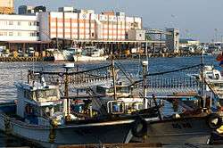 Seogwipo Limanı |
|
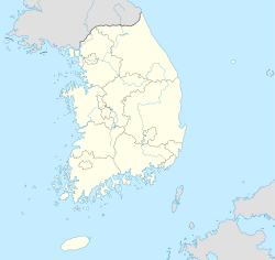 Seogwipo Seogwipo'nun Güney Kore'deki konumu |
|
| Koordinatlar: 33°15′10″K 126°33′40″D / 33.25278°K 126.56111°D | |
| Ülke | |
|---|---|
| Bölge | Jeju |
| İl | Jeju |
| Yüzölçümü | |
| - Toplam | 870,68 km2 (336,2 mi2) |
| Nüfus (2012) | |
| - Toplam | 155.691 |
| - Yoğunluk | 178,82/km² (463,1/sq mi) |
| Zaman dilimi | KST (+9) |
| İnternet sitesi: www.seogwipo.go.kr | |
Seogwipo (Korece: 서귀포시, 西歸浦市; Seogwipo-si), Güney Kore'nin Jeju ilinde bulunan bir şehirdir. Yüzölçümü 870.68 km² olan şehrin nüfusu 31 Aralık 2011 tarihi itibari ile 155,691'dir.
2006 yılında Namjeju ilçesi Seogwipo şehrine katılmıştır.[1]
Kardeş şehirler
Kaynaklar
- ↑ "Seogwipo, a history". Jeju Weekly. 3 Ekim 2015 tarihinde kaynağından arşivlendi. http://web.archive.org/web/20151003153023/http://www.jejuweekly.com/news/articleView.html?idxno=2609. Erişim tarihi: 17 Haziran 2015.
Dış bağlantılar
| ||||||||

This article is issued from Vikipedi - version of the 9/27/2016. The text is available under the Creative Commons Attribution/Share Alike but additional terms may apply for the media files.