Anvers (il)
Koordinatlar: 51°13′K 4°25′D / 51.217°K 4.417°D
Başlığın diğer anlamları için Anvers sayfasına bakınız.
| Anvers İli Provincie Antwerpen (Felemenkçe) | |
|---|---|
 |  |
| Bilgiler | |
| Ülke | |
| Bölge | Flaman Bölgesi |
| Topluluk | Flaman Topluluğu |
| Başkent | |
| Toplam nüfus | 1.688.493 (01/01/2006) |
| Yüz ölçümü | 2.867 km² |
| Arrondissement | Anvers Malines Turnhout |
| ISO 3166-2 | BE-VAN |
| Resmî site | www.provant.be |
| Konum | |
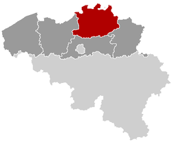 | |
| 70 Belediyeler | |
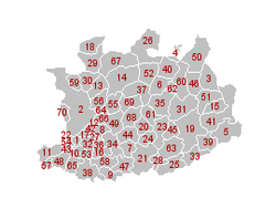 | |
Anvers İli (Felemenkçe: provincie Antwerpen, Fransızca: province d'Anvers) Belçika'nın Flaman Bölgesinde bulunan bir ildir.
Merkez şehri Anvers'tir.
Ayrıca bakınız
| ||||||||
This article is issued from Vikipedi - version of the 10/13/2016. The text is available under the Creative Commons Attribution/Share Alike but additional terms may apply for the media files.