Bornholm
Koordinatlar: 55°07′30″K 14°55′00″D / 55.125°K 14.9166667°D
| Bornholm | |
| — Kasaba — | |
 Østerlars Kilisesi, Bornholm'un beş dairesel kilisesinden biri |
|
 |
|
 Bornholm |
|
| Koordinatlar: 55°07′30″K 14°55′00″D / 55.125°K 14.9166667°D | |
| Ülke Bölge Şehir | Danimarka Bornholm |
|---|---|
| Nüfus (2010) | |
| - Toplam | 42.154 |
| Zaman dilimi | Orta Avrupa Zaman Dilimi (+1) |
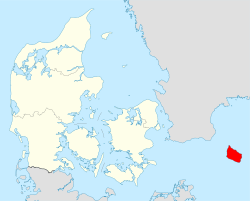
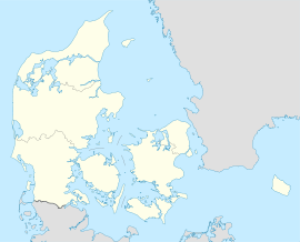
Bornholm, Danimarka'nın Baltık Denizi'nde bulunan adası.
İleri okumalar
- Lucazin, M (2010), Utkast till ortografi över skånska språket med morfologi och ordlista. Första revisionen, ISBN 978-91-977265-2-8, http://www.maniskor.se/isbn9789197726528.pdf Outlined scanian orthography including morphology and word index. First revision.
- Lucazin, M (2010), Utkast till ortografi över skånska språket med morfologi och ordlista, ISBN 978-91-977265-1-1, http://www.maniskor.se/isbn9789197726511cropmarked.pdf Outlined scanian orthography including morphology and word index.
Dış bağlantılar
- Municipality's official website (Dansk+Deutsch+English)
- Turistguide Bornholm (Dansk+Deutsch+English)
- Krak searchable/printable municipality map(Danca)
- Bornholm Map and Web Index
- Bornholm's Museum (Dansk+Deutsch+English+Polski)
- Municipal statistics: NetBorger Kommunefakta, delivered from KMD aka Kommunedata (Municipal Data) (Danish)
- Bornholm (Polish)
- Frit Bårrijnhålm / Free Bornhom (Bornholmian+Danish+English)
This article is issued from Vikipedi - version of the 8/10/2016. The text is available under the Creative Commons Attribution/Share Alike but additional terms may apply for the media files.