Brooklyn
Koordinatlar: 40°41′34″K 73°59′25″B / 40.69278°K 73.99028°B
| Brooklyn | |
| Kings County | |
 |
|
 |
|
| Koordinatlar: 40°41′34″K 73°59′25″B / 40.69278°K 73.99028°B | |
| Ülke | |
|---|---|
| Yüzölçümü | |
| - Toplam | 96,9 sq mi (251 km2) |
| - Su | 37,4 mi2 (96,90 km2) |
| Nüfus | |
| - Toplam | 2.567.098 |
| - Yoğunluk | 36.356/sq mi (14.037,1/km²) |
| Zaman dilimi | ZD () |
| Posta kodu | 112 |

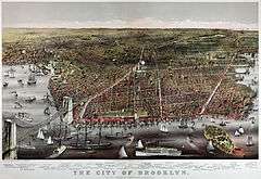
1879 yılında Brooklyn, sol tarafında Brooklyn Köprüsü, sağ tarafında Governors Island görünmektedir (Currier and Ives, 1879)
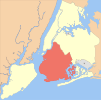
Brooklyn (veya Kings County), New York City'nin beş bölgesinden biridir.
Manhattan'a Brooklyn Köprüsü'yle bağlanır. Gelir düzeyi yüksek insanların muhiti olan Brooklyn Heights burada bulunur. Queens ilçesi ile komşudur. Manhattan ile aralarında East River (Doğu Nehri) bulunur. 2,5 milyonluk nüfusuyla ABD'deki en kalabalık ilçedir.
New York ilçeleri (özet) | ||||
| Jurisdiction | Nüfus | Yüz ölçümü | ||
| Borough (New York ilçesi) | County of | estimate for 1 Temmuz 2009 | (sq mi) square miles | km² |
| Manhattan | New York | 1,629,054 | 23 | 59 |
| the Bronx | Bronx | 1,397,287 | 42 | 109 |
| Brooklyn | Kings | 2,567,098 | 71 | 183 |
| Queens | Queens | 2,306,712 | 109 | 283 |
| Staten Island | Richmond | 491,730 | 58 | 151 |
| 8,391,881 | 303 | 786 | ||
| 19,541,453 | 47,214 | 122,284 | ||
| Source: United States Census Bureau[1][2][3] | ||||
Kaynakça
- ↑ U.S. Census Bureau, Population Division, Table 5. Annual Estimates of the Resident Population for Minor Civil Divisions in New York, Listed Alphabetically Within County: April 1, 2000 to July 1, 2009 (SUB-EST2009-05-36) and Table 1. Annual Estimates of the Resident Population for Incorporated Places Over 100,000, Ranked by July 1, 2009 Population: April 1, 2000 to July 1, 2009 (SUB-EST2009-01), Release Date: June 2010, retrieved on July 31, 2010
- ↑ County and City Data Book:2007 (U.S. Census Bureau), Table B-1, Area and Population, retrieved on July 12, 2008. New York County (Manhattan) was the nation's densest-populated county, followed by Kings County (Brooklyn), Bronx County, Queens County and San Francisco, California.
- ↑ American Fact Finder (U.S. Census Bureau): New York by County - Table GCT-PH1. Population, Housing Units, Area, and Density: 2000 Data Set: Census 2000 Summary File 1 (SF 1) 100-Percent Data, retrieved on February 6, 2009
This article is issued from Vikipedi - version of the 8/26/2016. The text is available under the Creative Commons Attribution/Share Alike but additional terms may apply for the media files.