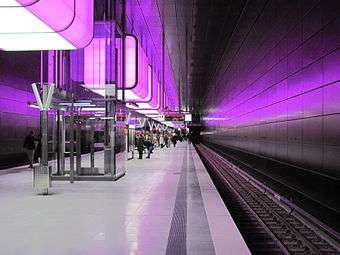
Hamburg metrosu
 | |||
 | |||
| Genel | |||
|---|---|---|---|
| Sahibi | Hamburger Hochbahn AG | ||
| Hizmet alanı | Hamburg, Norderstedt, Ahrensburg, Großhansdorf | ||
| Taşıma türü | Metro | ||
| Hat sayısı | 4 | ||
| İstasyon sayısı | 91 | ||
| Günlük yolcu sayısı | 597,260 (2013) | ||
| Yıllık yolcu sayısı | 218 milyon (2013)[1] | ||
| Web sitesi | Hochbahn | ||
| Hizmet | |||
| Hizmete giriş | 1 Aralık 1913) | ||
| İşletmeci(ler) | Metrovías | ||
| Taşıt sayısı | 245 tren | ||
| Tren uzunluğu | ~120 metre (390 ft) | ||
| Teknik | |||
| Sistem uzunluğu | 1.047 km (650.6 mi) | ||
| Elektriklendirme | 750 V DC Third rail | ||
| En yüksek hız | 80 km/h (50 mph) | ||
| |||
Hamburg metrosu (Almanca: Hamburg U-Bahn) Almanya'nın Hamburg, Norderstedt and Ahrensburg bölgelerinde bulunan metro istasyonu. İlk hattı 1912 yılında açılmıştır.[2] 4 Hat 91 istasyon ile hizmet vermektedir.[3]
Metro Bağlantıları
| Hat | Güzergah | Araçlar | İlk açılış |
Uzaklık (km) |
İstasyonlar |
|---|---|---|---|---|---|
| U1 | Norderstedt Mitte – Jungfernstieg – Hauptbahnhof Süd – Ohlstedt / Großhansdorf | DT3, DT4 | 1914 | 55.8 km | 46 |
| U2 | Niendorf Nord – Jungfernstieg – Hauptbahnhof Nord – Mümmelmannsberg | DT4 | 1913 | 24.3 km | 25 |
| U3 | Barmbek – Circle – Barmbek – Wandsbek-Gartenstadt | DT3, DT5 | 1912 | 20.6 km | 25 |
| U4 | HafenCity Universität – Jungfernstieg – Hauptbahnhof Nord – Billstedt | DT4, DT5 | 2012 | 12.2 km | 11 |
| TOPLAM: | 104.7 km | 91 | |||
| Hat | Kuzey / Batı 'dan Güney / Doğu 'ya uzanır. |
Duraklar (İstasyon terminalleri kalın harflerle) |
|---|---|---|
| U1 | Langenhorner Bahn | Norderstedt Mitte – Richtweg – Garstedt – Ochsenzoll – Kiwittsmoor – Langenhorn Nord – Langenhorn Markt – Fuhlsbüttel Nord – Fuhlsbüttel – Klein Borstel – Ohlsdorf (S1, S11) |
| Ohlsdorf branch | Ohlsdorf – Sengelmannstraße – Alsterdorf – Lattenkamp – Hudtwalckerstraße – Kellinghusenstraße (U3) | |
| KellJung-Linie | Kellinghusenstraße – Klosterstern – Hallerstraße – Stephansplatz – Jungfernstieg (U2, U4, S1, S2, S3, Alster ferries) | |
| Meßberglinie | Jungfernstieg – Meßberg – Steinstraße – Hauptbahnhof Süd (U3, S1, S11, S2, S21, S3, S31) | |
| Wandsbek extension | Hauptbahnhof Süd – Lohmühlenstraße – Lübecker Straße (U3) – Wartenau – Ritterstraße – Wandsbeker Chaussee (S1, S11) – Wandsbek Markt – Straßburger Straße – Alter Teichweg – Wandsbek-Gartenstadt (U3) | |
| Walddörferbahn | Wandsbek-Gartenstadt – Trabrennbahn – Farmsen – Berne – Meiendorfer Weg – Volksdorf
| |
| Volksdorf – Buckhorn – Hoisbüttel – Ohlstedt
| ||
| Volksdorf – Buchenkamp – Ahrensburg West – Ahrensburg Ost – Schmalenbeck – Kiekut – Großhansdorf
| ||
| U2 | Niendorf extension | Niendorf Nord – Schippelsweg – Joachim-Mähl-Straße – Niendorf Markt – Hagendeel – Hagenbecks Tierpark |
| Eimsbüttel branch | Hagenbecks Tierpark – Lutterothstraße – Osterstraße – Emilienstraße – Christuskirche – Schlump (U3) | |
| Diameter route | Schlump – Messehallen – Gänsemarkt – Jungfernstieg (U1, U4, S1, S2, S3, Alster ferries) – Hauptbahnhof Nord (U4, S1, S11, S2, S21, S3, S31) – Berliner Tor (U3, U4, S1, S11, S2, S21) | |
| Billstedt branch | Berliner Tor – Burgstraße – Hammer Kirche – Rauhes Haus – Horner Rennbahn – Legienstraße – Billstedt – Merkenstraße – Steinfurther Allee – Mümmelmannsberg | |
| U3 | Ring (Circle Line) |
Barmbek (U3, S1, S11) – Saarlandstraße – Borgweg – Sierichstraße – Kellinghusenstraße (U1) – Eppendorfer Baum – Hoheluftbrücke – Schlump (U2) – Sternschanze (S11, S21, S31) – Feldstraße – St. Pauli – Landungsbrücken (S1, S2, S3, Elbe ferries) – Baumwall – Rödingsmarkt – Rathaus (Jungfernstieg: U1, U2, U4, S1, S2, S3) – Mönckebergstraße – Hauptbahnhof Süd (U1, S1, S11, S2, S21, S3, S31) – Berliner Tor (U2, U4, S1, S11, S2, S21) – Lübecker Straße (U1) – Uhlandstraße – Mundsburg – Hamburger Straße – Dehnhaide – Barmbek (U3, S1, S11) |
| Walddörferbahn | Barmbek – Habichtstraße – Wandsbek-Gartenstadt (U1) | |
| U4 | HafenCity Bahn | HafenCity Universität – Überseequartier – Jungfernstieg (U1, U2, S1, S2, S3) |
| Diameter route | Jungfernstieg – Hauptbahnhof Nord (U2, S1, S11, S2, S21, S3, S31) | |
| Billstedt branch | Hauptbahnhof Nord – Berliner Tor (U2, U3, S1, S11, S2, S21) – Burgstraße – Hammer Kirche – Rauhes Haus – Horner Rennbahn – Legienstraße – Billstedt | |
| |
Rothenburgsorter Hochbahn
|
Hauptbahnhof Süd (U1, U3, S1, S11, S2, S21, S3, S31) – Spaldingstraße – Süderstraße – Brückenstraße – Rothenburgsort (S2, S21) |
Kaynakça
- ↑ http://www.hochbahn.de/wps/portal/de/home/hochbahn/unternehmen/die_hochbahn/unternehmen_auf_einen_blick?1dmy¤t=true&urile=wcm:path:/wps/wcm/connect/hochbahn_content/home/hochbahn/unternehmen/die_hochbahn/unternehmen_auf_einen_blick Hochbahn Portal
- ↑ "Historie der HOCHBAHN [History of the U-Bahn]" (German). Hamburger Hochbahn. 2013. http://www.hochbahn.de/wps/portal/de/home/hochbahn/unternehmen/historie/?WCM_PORTLET=PC_7_QI5C5I930GON002FVCDEUT00A7000000_WCM&WCM_GLOBAL_CONTEXT=/wps/wcm/connect/de/home/hochbahn/unternehmen/historie/. Erişim tarihi: 2013-09-30.
- ↑ "HOCHBAHN - Annual Report 2012 - THINKING FURTHER! TURNING VISIONS INTO REALITY". Hamburger Hochbahn. 2012. ss. 4. http://www.hochbahn.de/wps/wcm/connect/a7981d00404d5dd89462d4ccf66c0340/130624_HHA_UB12_E_online.pdf?MOD=AJPERES. Erişim tarihi: 2013-09-30.
Dış bağlantılar
- Resmî site Operator of the Hamburger U-Bahn
- Die Geschichte der Hamburger Hochbahn Book by André Loop
- Current and historical Plans for the U4
| ||||||||||
This article is issued from Vikipedi - version of the 11/19/2016. The text is available under the Creative Commons Attribution/Share Alike but additional terms may apply for the media files.
.png)